
-
 Korea.net's 24-hour YouTube channel
- NEWS FOCUS
- ABOUT KOREA
- EVENTS
- RESOURCES
- GOVERNMENT
- ABOUT US


View this article in another language
- 한국어
- English
- 日本語
- 中文
- العربية
- Español
- Français
- Deutsch
- Pусский
- Tiếng Việt
- Indonesian
A new technology will allow sailors and navigators to embark on their voyage more easily and more safely.
The Korea Hydrographic and Oceanographic Agency (KHOA), part of the Ministry of Oceans and Fisheries, released a statement on Jan. 10 stating that it had developed a 3-D electronic navigation system. This is a technology that sailors will use to see close-ups of ship traffic on and under the sea in three dimensions, similar to navigation devices found in many cars.
With the 3-D nautical navigation system, captains will be able to see boats and ships in surrounding waters, as well as the seafloor topography.
Existing electronic marine navigation systems have some setbacks, as the crew can only update the system by CD and can only see traffic on the water and the underwater topography through 2-D spots and lines.
The new 3-D technology gets updates via Wi-Fi and crewmen now have access to a range of necessary information in real-time via the Internet, information about tidal currents and weather forecasts, too.
This technology is one of the results of a thorough bathymetric survey carried out by the KHOA using state-of-the-art equipment. A 3-D structure of water levels, in particular around quays and ports, has been mapped in a manner so that sea levels are distinguished in different colors and rocks and other underwater obstacles take shape. This gives better visibility at a glance.
"With this new navigation system in place, we'll have safer trips, as we'll be able to download any nautical information in real-time," said an official from the KHOA. "Currently, most boats and ships use an outdated GPS plotter. This new 3-D GPS plotter will ensure safer and easier fishery activities.”
By Sohn JiAe
Korea.net Staff Writer
Photos: the Korea Hydrographic and Oceanographic Agency, KBS
jiae5853@korea.kr
The Korea Hydrographic and Oceanographic Agency (KHOA), part of the Ministry of Oceans and Fisheries, released a statement on Jan. 10 stating that it had developed a 3-D electronic navigation system. This is a technology that sailors will use to see close-ups of ship traffic on and under the sea in three dimensions, similar to navigation devices found in many cars.
With the 3-D nautical navigation system, captains will be able to see boats and ships in surrounding waters, as well as the seafloor topography.
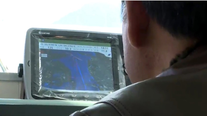
A sailor runs a pilot test on a new 3-D electronic navigation system.
Existing electronic marine navigation systems have some setbacks, as the crew can only update the system by CD and can only see traffic on the water and the underwater topography through 2-D spots and lines.
The new 3-D technology gets updates via Wi-Fi and crewmen now have access to a range of necessary information in real-time via the Internet, information about tidal currents and weather forecasts, too.
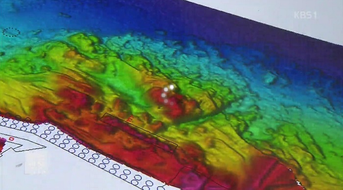
This technology is one of the results of a thorough bathymetric survey carried out by the KHOA using state-of-the-art equipment. A 3-D structure of water levels, in particular around quays and ports, has been mapped in a manner so that sea levels are distinguished in different colors and rocks and other underwater obstacles take shape. This gives better visibility at a glance.
"With this new navigation system in place, we'll have safer trips, as we'll be able to download any nautical information in real-time," said an official from the KHOA. "Currently, most boats and ships use an outdated GPS plotter. This new 3-D GPS plotter will ensure safer and easier fishery activities.”
A new 3-D electronic navigation system distinguishes water depth with different colors.
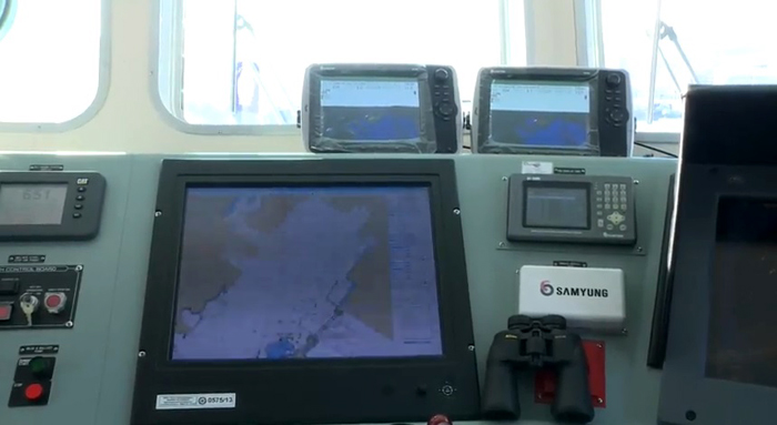
Many ships are now equipped with new 3-D electronic navigation systems.
By Sohn JiAe
Korea.net Staff Writer
Photos: the Korea Hydrographic and Oceanographic Agency, KBS
jiae5853@korea.kr
Most popular


KOREA.net
Copyright © Ministry of Culture, Sports and Tourism