As summer nears, the mountains in Korea are turning green and tree leaves and flowers are blossoming. This section profiles the best places in Seoul for walking, jogging and biking. For those living in or visiting the capital, enjoying outdoor spots in early summer is recommended before the mercury rises.
By Kim Hyelin, Elias Molina and Lee Jihae
A spot in Seoul offers a panoramic view of the capital without the need to reach the top of a skyscraper. Hanyangdoseong or Seoul City Wall, surrounds downtown.
Hanyang, the old name for Seoul, was the capital of the Joseon Dynasty (1392-1910), and the term "Doseong" means "a fortress surrounding a country's capital). The fortress that once protected Hanyang is now a trail popular with Seoul residents.
Hanyangdoseong was built in 1396 (the fifth reign of King Taejo) to mark the boundaries of the capital's government and protect the city from invasion. Its average height is 5-8 m and its length spans 18.6 km. Among fortresses worldwide, this one served its mission for the longest time (1396-1910).
Many sections of the structure were destroyed during Japanese annexation of the Korean Peninsula in the early 20th century. Restoration work that began in 1968, however, rebuilt a significant portion of the original facade. As of last year, about 70% or 13.7 km of the fortress remains or has been restored.
The six trails in or around Hanyangdoseong are the Baegak Trail, which spans Changuimun Gate to Hyehwamun Gate; Naksan Mountain Trail (Hyehwamun to Heunginjimun Gate); Heungjinmun Gate Trail (Heunginjimun to Jangchung Gymnasium); Namsan Mountail Trail (Jangchung to Baekbeom Square); Sungnyemun Gate Trail (Baekbeom to the site of Donuimun Gate); and Inwangsan Mountain Trail (Donuimun to Changuimun).
On a spring day last month, Korea.net staff walked along the Baegak and Inwangsan trails, both which are the most difficult among the six, with guide Lee Seung Real.
Walking along the Donuimun site and along the fortress structures, we soon reached the entrance of Inwangsan, which required the mustering of leg strength. The mountain is rocky and thus certain parts required climbing rocks and the many stairs there made it feel as if we were climbing more than walking.
Many often get worn out if they start the trail thinking it is easy. When visiting this trail, hikers are recommended to bring drinking water and snacks and wear comfortable shoes and clothes. The reward for putting aside one's breath to make this strenuous effort is a panoramic view of Seoul.
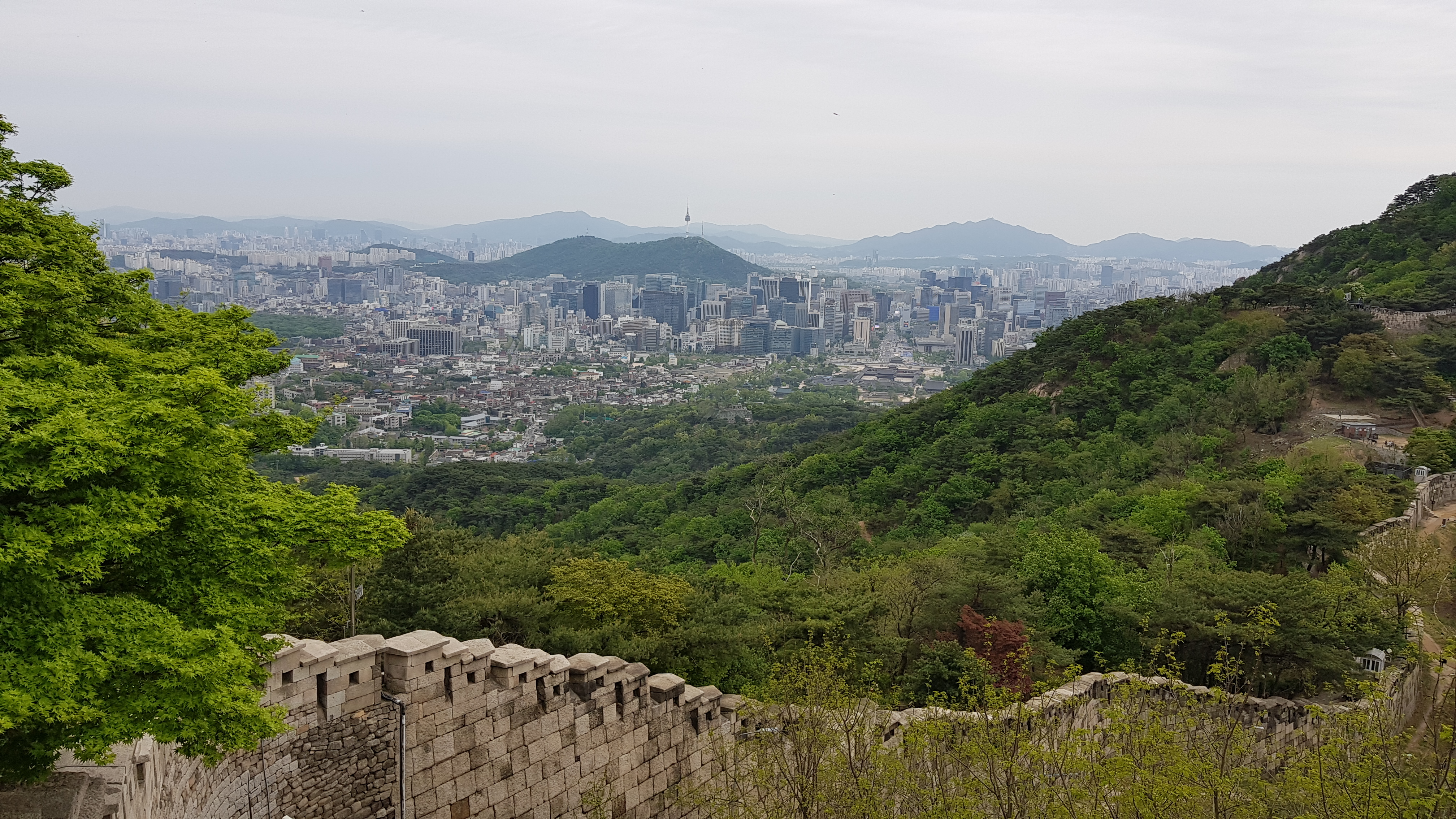
This is a view of Seoul as seen from the Baegak Mountain Trail of Hanyangdoseong (Seoul City Wall). (Kim Hyelin)
When seen from within the city, Seoul looks like a dense forest of buildings. From high above, however, a picture of a massive yet charming metropolis appears. We took photos and cooled off before moving on to the Baegak trail.
Opened to the public in 2007, this trail has below it major government offices including Cheong Wa Dae. Thus taking photos or filming videos at certain parts of the trail is prohibited. We snapped shots of what we could and headed toward the peak.
The blue sky, neat walls, forest scent and the panoramic view of the city all formed a perfect harmony on the trail. Guide Lee said, "The section from Changuimun Gate to Baegakmaru fortress blends with the ramparts along the steep slope and the panoramic view of the city. This has the best scenery of all Hanyangdoseong trails."
The path on this section comprises entirely stairs for safety and going on it feels like climbing, just like on the Inwangsan trail. Yet the beautiful scenery made us forget our exhaustion with each and every step.
Baegakmaru is the highest point of the fortress. Once we reached it, we saw in a single view Gyeongbokgung Palace and Sejongno, the main street that runs through Jongno-gu District, as well the mountains surrounding Seoul. Once we walked down to Baegakmaru, we arrived at Hyehwamun, where the Naksan trail begins and the Baegak trail ends.
We looked around the fortress while listening to the guide's in-depth explanation. We had completed only two trails but the sun was starting to set. To learn the history of the fortress, hiring a guide is highly recommended, but not for simply walking on trails over a given time. The guides speak Korean only and can be hired exclusively through online reservations.
One of the joys of completing a trail is collecting stamps, which are available at the beginning of each trail. A visitor earns a badge confirming the completion of the trails if he or she collects all four.
More information on the guides, stamp tours and each trail is offered in Korean, Chinese, English and Japanese on the Hanyangdoseong website (https://seoulcitywall.seoul.go.kr/front/eng/index.do).
|
1. Inwangsan Mountain Trail (Site of Donuimun Gate to Changuimun Gate) |
kimhyelin211@korea.kr