Identification of the East Sea in Ancient Western Maps
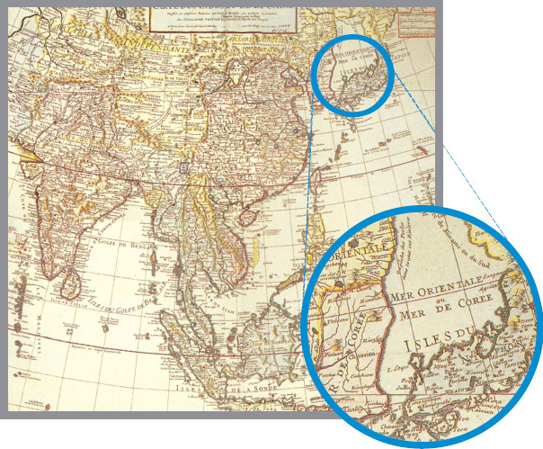 MER ORIENTALE, MER DE COREE, 1705 - The map shows the dual usage of MER ORIENTALE (Oriental Sea) and MER DE COREE (Sea of Korea)
It was in the early 16th century that the sea area between the Korean peninsula and the Japanese archipelago began to appear on world maps following worldwide voyages of discovery. From the 16th to the early 19th century, Westerners used various names for this sea, including Sea of Joseon, Sea of Korea, Eastern Sea, Oriental Sea, Sea of China, and Sea of Japan, but the name used most frequently was indisputably Sea of Korea.
Beginning in the mid-19th century, however, the name Sea of Japan began to appear as often as Sea of Korea, and, beginning in the late 19th century, the former started to gain wider acceptance. Since the early 20th century, the name Sea of Japan has been used for the most part on world maps and in publications.
The nautical chart which Jean Francois de Galaup, comte de La Perouse, a French explorer and naval officer, published in 1797 after his marine expedition to Korea, Japan, and Russia (Sakhalin), and another map of the Pacific drawn by John Arrowsmith, an English geographer, in 1798, identified the sea in question as Sea of Japan. After that, the name Sea of Korea appeared less frequently.
Since the late 19th century, most maps have used the name Sea of Japan. When the Russo-Japanese War broke out, major newspapers around the world used that name in their articles and since the Japanese colonial rule of Korea, it has become the most widely accepted name for the sea.
East Sea in Korean Writings and Ancient Maps
The first recorded use of the name East Sea can be traced back to a description of King Dongmyeong of the Goguryeo Kingdom in Samguksagi (History of Three Kingdoms, 1145), Korea's oldest history book. Samguksagi contains 13 poems that refer to the East Sea, and Samgukyusa (Memorabilia of the Three Kingdoms, 1281), has 15.
One of Korea's oldest atlases, Sinjeung-donggukyeojiseungnam (Newly Expanded Survey of the Geography of Korea, 1530) includes maps of Gyeongsang, Hamgyeong, and Gangwon provinces which clearly refer to the sea as Great Sea of the Lower East (Dongjeodaehae).
The oldest known map among those that use the exact name East Sea (Donghae) is the Map of Yeongnam, which Joseon's Border Defense Council (Bibyeonsa) produced in the late 1740s.
The name Sea of Japan first appeared in 1602 in a map called Mappa Mondo (Complete Map of the World) drawn by Matteo Ricci, an Italian Catholic missionary who was based in Beijing.
International Norms
The United Nations Conference on the Standardization of Geographical Names (UNCSGN) and the International Hydrographic Organization (IHO) are the two international organizations which provide applicable guidelines when two or more countries sharing a geographical feature do not agree on a common name.
○ United Nations Conference on the Standardization of Geographical Names
UNCSGN Resolution III/20 (1977) recommends that when a geographical feature is under the sovereignty of more than one country or is divided among two or more countries and the countries sharing a given geographical feature do not succeed in agreeing on a common name, it should be a general rule of international cartography that the name used by each of the countries concerned will be accepted.
○ International Hydrographic Organization
IHO Technical Resolution A 4.2.6 (1974) recommends that in a situation where two or more countries share a given geographical feature (for example, a bay, strait, channel or archipelago) and use different name forms, they should endeavor to reach agreement to affix a single name to the feature concerned. If they have different official languages and cannot agree on a common name form, it is recommended that the name forms of each of the languages in question should be accepted for charts and publications unless technical reasons prevent this practice on small single charts, e.g. English Channel/La Manche.
