
-
 Korea.net's 24-hour YouTube channel
- NEWS FOCUS
- ABOUT KOREA
- EVENTS
- RESOURCES
- GOVERNMENT
- ABOUT US


View this article in another language
- 한국어
- English
- 日本語
- 中文
- العربية
- Español
- Français
- Deutsch
- Pусский
- Tiếng Việt
- Indonesian
The southeastern shore of the Korean Peninsula boasts a beautiful coastline, with spectacular scenery of endless beaches and a deep blue sea. The lack of sufficient transportation has made it difficult to get a close look at this part of the country, but a recently inaugurated walking path aims to fix that. The Blue Road footpath winds along the shoreline of Yeongdeok County, Gyeongsangbuk-do (North Gyeongsang Province), a fishing town famous for snow crabs, making it now easier for people to take a walking tour along the coast. The southernmost section of the trail between Snow Crab Park and the Samsa Marine Park was recently completed, connecting all four sections of the Blue Road.
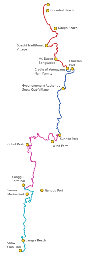
The Blue Road is a part of the Haeparang Trail walking trail that stretches from Busan in the south to Goseong, Gangwon-do (Gangwon Province), in the north. The English name of Yeongdeok’s Blue Road stands for: Beach, Legend, Utopia and Energy. It is 64 kilometers long and takes 20 hours to walk all the way.
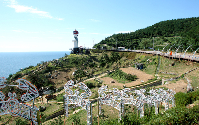
Part of the Blue Road is the Blue Snow Crab Promenade (B course), in blue on the map. Here, visitors can see the endless sea stretching out to the horizon. It is the most popular of the Blue Road’s four sections. Sunrise Park, located at the southern end of this section, covers 150,000 square meters and is full of trees and wild flowers. The name of this section comes from the fact that people can take in the scenery of an East Sea fishing village and have the chance to taste snow crab. Walking up to the observatory on Jukdosan Mountain (700 meters), visitors can see the beauty of Chuksan Port, at the northern end of this section.
Continuing on to the south is the Light and Wind Promenade (C course), in purple on the map. It lies between Ganggu Port and Sunrise Park. Tourists come here to see Gubul Peak and the Yeongdeok Wind Power complex. Gobul Peak is only 235 meters high, but, from the top, people get a 180-degree view of the surrounding area. They can even see as far as Ganggu Port to the south and as far as Dongdaesan Mountain and its ridgeline. The Sunrise Park, at the northern end of this section, was built along the coast road. In the spring, wild flowers spread along the walking path. The observatory and the reed forest nearby are also beautiful.
The northernmost section of the Blue Road is the Mokeun Promenade of Contemplation (A course), in red on the map, between Chuksan Port and Goraebul Beach. Along here, you can see the ancient Daesosan Bongsudae, a traditional beacon tower. Climbing up the stone tower, people get a view of the surrounding area. There are also two other beacon towers in the county. Across from the Daesosan Bongsudae, there is an outdoor amphitheater. Small performances are held here during full moons.
The Blue Road trail along the east coast is one of the most popular spots for hikers. In 2012, the Korea Tourism Organization (KTO) chose it as one of the 99 places people must visit and the Ministry of Culture, Sports and Tourism (MSCT) has selected it as one of the seven ecological trails in the country.
“We plan to build additional facilities for the convenience of our visitors and we hope to relate the history of each section of our Blue Road,” said a Yeongdeok County official.
- Transportation: Nine buses depart daily from the Dong (East) Seoul Terminal for the Yeongdeok Bus Terminal.
- Blue Road travel info: +82-54-730-6514, http://blueroad.yd.go.kr/en/open_content/main_page/
- Yeongdeok County travel info: +82-54-730-6114, http://tour.yd.go.kr/main_eng.aspx
By Limb Jae-un
Korea.net Staff Writer
jun2@korea.kr

The Blue Road is a part of the Haeparang Trail walking trail that stretches from Busan in the south to Goseong, Gangwon-do (Gangwon Province), in the north. The English name of Yeongdeok’s Blue Road stands for: Beach, Legend, Utopia and Energy. It is 64 kilometers long and takes 20 hours to walk all the way.
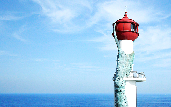
The East Sea, as seen from the Changpomal Lighthouse, a Yeongdeok landmark (photo courtesy of Yeongdeok County)
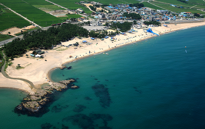
Jangsa Beach is located at the southern end of the Blue Road. (photo courtesy of Yeongdeok County)
Part of the Blue Road is the Blue Snow Crab Promenade (B course), in blue on the map. Here, visitors can see the endless sea stretching out to the horizon. It is the most popular of the Blue Road’s four sections. Sunrise Park, located at the southern end of this section, covers 150,000 square meters and is full of trees and wild flowers. The name of this section comes from the fact that people can take in the scenery of an East Sea fishing village and have the chance to taste snow crab. Walking up to the observatory on Jukdosan Mountain (700 meters), visitors can see the beauty of Chuksan Port, at the northern end of this section.
Continuing on to the south is the Light and Wind Promenade (C course), in purple on the map. It lies between Ganggu Port and Sunrise Park. Tourists come here to see Gubul Peak and the Yeongdeok Wind Power complex. Gobul Peak is only 235 meters high, but, from the top, people get a 180-degree view of the surrounding area. They can even see as far as Ganggu Port to the south and as far as Dongdaesan Mountain and its ridgeline. The Sunrise Park, at the northern end of this section, was built along the coast road. In the spring, wild flowers spread along the walking path. The observatory and the reed forest nearby are also beautiful.
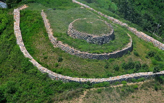
The northernmost section of the Blue Road is the Mokeun Promenade of Contemplation (A course), in red on the map, between Chuksan Port and Goraebul Beach. Along here, you can see the ancient Daesosan Bongsudae, a traditional beacon tower. Climbing up the stone tower, people get a view of the surrounding area. There are also two other beacon towers in the county. Across from the Daesosan Bongsudae, there is an outdoor amphitheater. Small performances are held here during full moons.
The Daesosan Bongsudae, an ancient beacon tower (photo courtesy of Yeongdeok County)
The Blue Road trail along the east coast is one of the most popular spots for hikers. In 2012, the Korea Tourism Organization (KTO) chose it as one of the 99 places people must visit and the Ministry of Culture, Sports and Tourism (MSCT) has selected it as one of the seven ecological trails in the country.
“We plan to build additional facilities for the convenience of our visitors and we hope to relate the history of each section of our Blue Road,” said a Yeongdeok County official.
The Sunrise Park features snow crab illuminations. (photo courtesy of Yeongdeok County)
The Blue Road trail in Yeongdeok County (image courtesy of Yeongdeok County)
- Transportation: Nine buses depart daily from the Dong (East) Seoul Terminal for the Yeongdeok Bus Terminal.
- Blue Road travel info: +82-54-730-6514, http://blueroad.yd.go.kr/en/open_content/main_page/
- Yeongdeok County travel info: +82-54-730-6114, http://tour.yd.go.kr/main_eng.aspx
Haeparang Trail
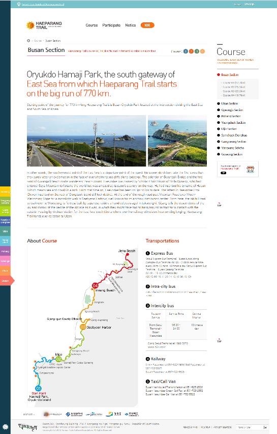
An English-language guide to the Haeparang Trail, a 770-kilometer walking route, was published online last month (www.haeparang.org). The newly developed hiking course winds northward along the East Sea from Oryukdo Park in Busan, in the southeast of the peninsula, to the Unification Observatory in Goseong, Gangwon-do (Gangwon Province), in the northeast corner of South Korea, near the DMZ and abutting North Korea.
The name for the series of walking paths and hiking trails, “Haeparang,” combines the Korean words for the sun, hae, and the word for blue, parang, describing the sun that rises in the east from the depths of the beautiful, blue East Sea.
The online guide provides, in English, satellite maps, route information, transportation schedules, course duration and a difficulty level for each of the 50 segments that make up Korea’s longest chain of walking tracks. The website will also have a calendar showing local festivals and fairs.
The Ministry of Culture, Sports and Tourism will provide simplified Chinese and Japanese services by early 2014, as well as the original Korean.
A guide to the Haeparang Trail is now available in English.
By Limb Jae-un
Korea.net Staff Writer
jun2@korea.kr
Related Contents

Most popular
- First hearing-impaired K-pop act hopes for 'barrier-free world'
- 'Mad Max' director impressed by 'cinema-literate' Korean viewers
- Romanian presidential couple visits national cemetery
- 'Korean mythology is just as wonderful as Greek and Roman'
- President Yoon, Japan PM pledge better trilateral ties with US


KOREA.net
Copyright © Ministry of Culture, Sports and Tourism