-
 Korea.net's 24-hour YouTube channel
- NEWS FOCUS
- ABOUT KOREA
- EVENTS
- RESOURCES
- GOVERNMENT
- ABOUT US


With the passage of the bill, the dual-name movement is now spreading across the U.S., as many other states, including New York, New Jersey, Georgia, Illinois, Washington and California, are considering following suit.
This is all part of a growing campaign to correct the nomenclature "Sea of Japan," unilaterally adopted by Japan when Korea was under Japanese colonial rule.
If history is any guide, the Japanese in earlier times actually called the stretch of water to their west as the “Sea of Korea,” rather than the “Sea of Japan” which they later adopted.
Indeed, the name “Sea of Korea” was not something used simply by the public or by scholars, but was officially adopted in formal documents exchanged between the Joseon Dynasty (1392-1910) and its newly-formed neighbor, the Meiji government.
A treaty signed by the Joseon Dynasty and Japan in January 1884 makes clear these issues. The “Trade Rules of Joseon and Japan” stipulated in its 41st article that, “Japanese fishing boats are allowed along the coast bordering Joseon’s four provinces, from Jeolla and Gyeongsang all the way up to Gangwon and Hamgyeong, while Korean boats are allowed to catch fish along the coast near Japan’s provinces, including Hizen, Chikuzen, and Iwami, facing the Sea of Korea.”
As part of the global efforts to shine some light on this issue, the Northeast Asian History Foundation, a Seoul-based historical research body, recently published a book of ancient maps. Its “East Sea and Dokdo in Old Maps” is the result of many years of collaboration and analysis of ancient maps from both Northeast Asia and beyond.
Concerning nomenclature, the study lays testimony to the fact that this body of water was most commonly referred to as the “East Sea.” In line with this labeling, it also repeatedly brings forth evidence showing that the Dokdo Islets, the easternmost outcroppings of Korean territory, have been “part of Korean territory,” both geographically and historically, since records began.
The book contains old maps that clearly label the body of water as the East Sea and state that the islands of Dokdo are in Korean territory. Many of the maps come from Western countries, including Germany, France and Britain, and there are even a few from Japan.
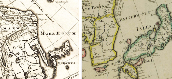
The body of water between Korea and Japan is labeled as the “MARE EOUM,” Latin for “A Sea in the East,” in the 1624 map by German geographer Philip Cluver (left). In the 1721 map by English royal geographer John Senex (right), it is called the “EASTERN SEA.”
The name Sea of Japan was occasionally used after the West got more actively engaged in trading with Japan. However, a collection of pre-18th century maps from Germany, England, Russia and even Japan, relates a different story.
In all these maps, the body of water is labeled as either the Sea of Korea or the Eastern Sea.
For example, the 1690 Map of Asia created by German geographer and historian Philip Cluver, included in his “Introduction in Universal Geography,” called the sea the “MARE EOUM,” or “Sea in the East” in Latin.
Also, John Senex, royal geographer of England, used the name “EASTERN SEA” in his 1721 map of India and China.
Official geographer to both French and Spanish kings, Nicolas de Fer, meanwhile, even wrote in his 1702 map that, “The East Sea is a sea called the ‘Orientale Sea’ by Tartars [an ethnic group from Russia], but it is unknown to Europeans.”
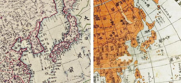
Two ancient Japanese maps both indicate that the body of water between Korea and the Japanese islands is called the “Sea of Korea” and label the Pacific Ocean as the “Great Japanese Sea.”
As well as Western maps, one can find many old Japanese maps that fail to use the words “Sea of Japan.” The Shintei Bangkoku Zenu map by Japanese cartographer and astronomer Takahashi Kageyasu named the stretch of water as the “Sea of Korea,” while calling the Pacific Ocean the “Great Japanese Sea.” Another Japanese cartographer, Kurihara Nobuaki, in his 1848 Touzai Chikyu Bangkoku Zenzu map, used the same names.
In these Japanese maps, meanwhile, the Japanese cartographers also recognize Dokdo as being Korean territory.
The Sangoku Tsuran Zustsu map, published by Hayashi Shihei in 1785, colored Dokdo the same shade of yellow as the Korean Peninsula, while a different color, a grayish-green, was assigned to its neighbor, the Japanese islands, distinguishing between the two states. To make it even clearer, next to the Dokdo Islets was a note: “Possessed by the Joseon Dynasty.”
Notably, a complete Japanese map dating back to 1877 clearly portrays the entire Japanese territory and excludes Dokdo, definitely running against some more recent Japanese claims to the islets.
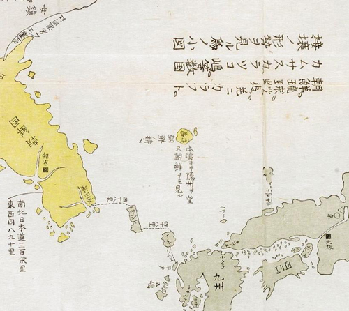
This 1783 Japanese map colors Dokdo (middle) in yellow, as it does the rest of the Korean Peninsula, with a note next to it saying, “Possessed by the Joseon Dynasty.”
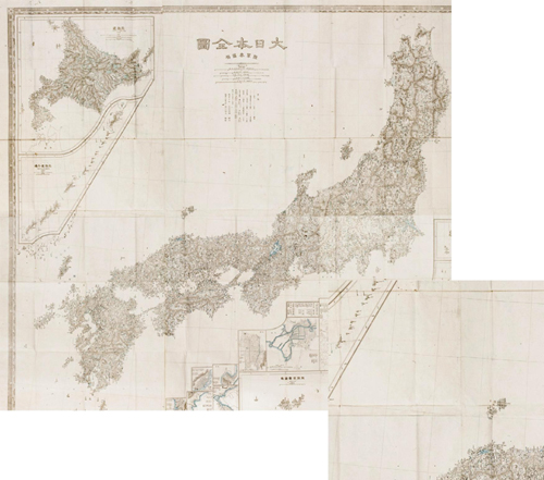
The Japanese map of 1877, mapping all lands and territories belonging to Japan, does not include Dokdo as Japanese territory.
Other western old maps describe Dokdo as being part of Korea, too, as evidenced in the Map of China by Jean Baptiste Bourguignon D’Anville, the French royal geographer, the Map of Joseon’s Eastern Seashore by Russian naval officers and the Kang Neung map by the French Army Map Service.
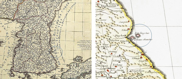
French royal geographer Jean Baptiste Bourguignon D’Anville labels Dokdo as “Tchian-chan-tao,” using the Mandarin pronunciation of its old name, Usando, in both his 1732 (left) and 1737 (right) maps.
According to the Northeast Asian History Foundation, with these exquisite old maps as primary historical documents, observers will now be able to understand that the body of water located to the east of the Korean Peninsula has long been called the East Sea and that the Japanese themselves have long considered Dokdo to be part of Korean territory.
(All photos courtesy of the Northeast Asian History Foundation)
By Wi Tack-whan, Sohn JiAe
Korea.net Staff Writers
whan23@korea.kr
Related Contents

Most popular
- First hearing-impaired K-pop act hopes for 'barrier-free world'
- 'Mad Max' director impressed by 'cinema-literate' Korean viewers
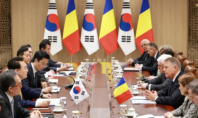
- Romanian presidential couple visits national cemetery
- 'Korean mythology is just as wonderful as Greek and Roman'
- President Yoon, Japan PM pledge better trilateral ties with US